
- الحصول على الرابط
- X
- بريد إلكتروني
- التطبيقات الأخرى
National Park Service sites receive approximately 280 million visitors each year and it publishes a ‘Ranking Report for Recreation Visits’ every year. This public usage list includes all NPS properties, not just National Parks, but also National Monuments (NM), National Historical Parks (NHP), National Seashores (NS), National Military Parks (NMP), National Recreation Areas (NRA), and so on as listed on the ranking report for 2012. The National Park Service says it has one mission, to “care for special places saved by the American people so that all may experience our heritage.” There are a total of 367 places on this list, but when it comes to only national parks — some with and without a preserve — what are the hidden gems among national treasures, the least crowded U.S. National Parks? If you want more of nature, and less of people, then you might be interested in visiting one that is less popular. Here’s a list starting at #25 and working down to the #1 least-visited, therefore least-crowded national parks in all of the United States during 2012. [50 Photos]
Share this:

#25 of the 59 U.S. National Parks: Virgin Islands National Park had 483,341 visitors in 2012, coming in with a rank of #119 of the #367 on the list. It is the 25th least-crowded national park in the U.S. This is Trunk Bay and the beach on Saint John, called the most beautiful beach in the world. It is continually listed in the top 10 beaches worldwide to visit. Photo #1 by Iliyan Gochev

Virgin Islands National Park has about 14,689 acres. NPS describes it as “Virgin Islands National Park’s hills, valleys and beaches are breath-taking. However, within its 7,000 plus acres on the island of St. John is the complex history of civilizations – both free and enslaved – dating back more than a thousand years, all who utilized the land and the sea for survival.” Photo #2 by Jason St Peter

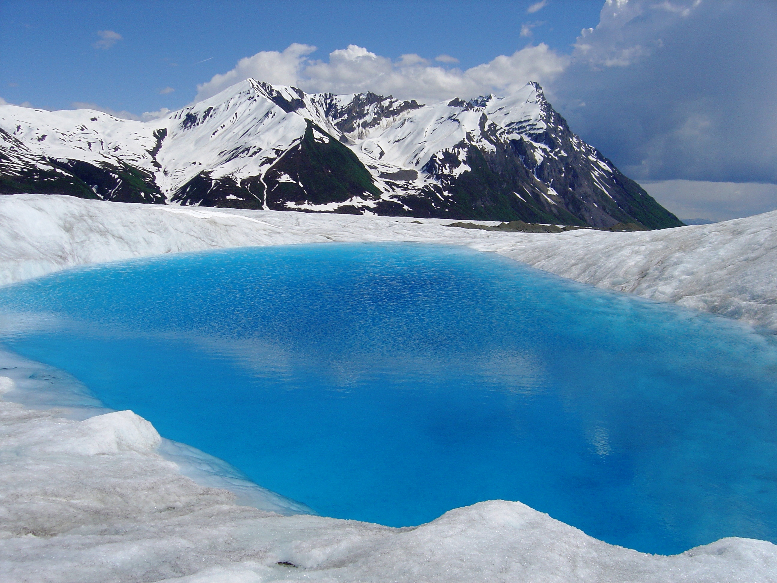
#24 in list of least-visited national parks: Glacier Bay National Park & Preserve in Alaska had 454,337 visitors in 2012. That may sound like a lot of people, but the park has 3,224,840 acres! Of all national park recreation sites, it ranked #125 in popularity based on the number of visitors. This is Fairweather Mountains and Margerie Glacier. Mount Fairweather is one of the world’s highest coastal mountains at 15,325 feet (4,671 meters). The Margerie Glacier is a 21-mile-long (34 km) tide water glacier. NPS describes the park as “Covering 3.3 million acres of rugged mountains, dynamic glaciers, temperate rainforest, wild coastlines, and deep sheltered fjords, Glacier Bay National Park is a highlight of Alaska’s Inside Passage and part of a 25-million acre World Heritage Site-one of the world’s largest international protected areas. From summit to sea, Glacier Bay offers limitless opportunities for adventure and inspiration.” Photo #3 by Emily Mount / NPS
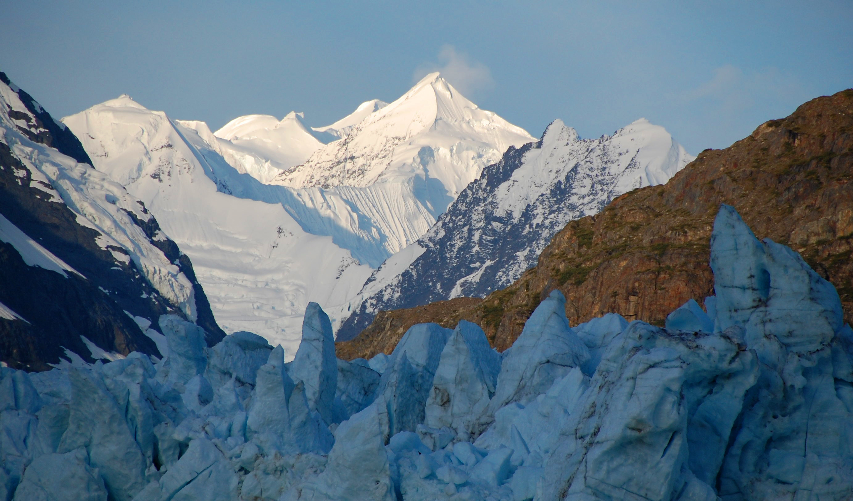

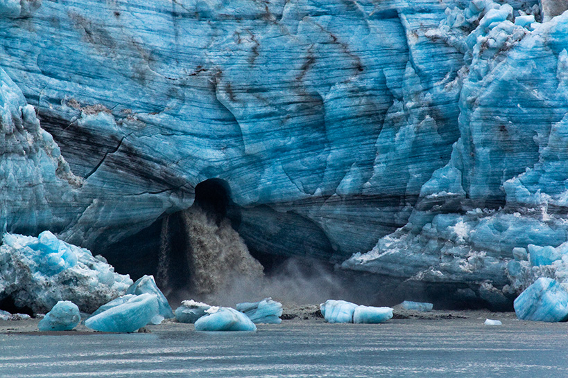
Waterfall beneath Lamplugh Glacier, one of the glaciers at Alaska’s Glacier Bay National Park and Preserve. While there are many reasons that this park is special, one of them is that there are no roads that lead directly to Glacier Bay. The park is mostly water, so most visitors see it from a cruise ship with thousands of other people. But boats come in all sizes and some adventurers see Glacier Bay from a kayak. Photo #4 by Larry Wilson / NPS

#23 in popularity of all U.S. National Parks. Canyonlands National Park service describes this park as: “Canyonlands invites you to explore a wilderness of countless canyons and fantastically formed buttes carved by the Colorado River and its tributaries. Rivers divide the park into four districts: the Island in the Sky, the Needles, the Maze, and the rivers themselves. These areas share a primitive desert atmosphere, but each offers different opportunities for sightseeing and adventure.” These formations are known as the “Needles.” 452,952 people visited in 2012, making this #126 of all NPS parks. Photo #5 by Jesse Varner

Mesa Arch, just one of many fascinating natural formations at the 337,597.8 acres of Canyonlands National Park. Photo #6 by John Fowler (snowpeak)

#22 for fewer visitors: The Crater Lake National Park service described it as: “Crater Lake has inspired people for thousands of years. No place else on earth combines a deep, pure lake, so blue in color; sheer surrounding cliffs, almost 2,000 feet high; two picturesque islands; and a violent volcanic past. It is a place of immeasurable beauty, and an outstanding outdoor laboratory and classroom.” In 2012, 447,251 visitors traipsed over its 183,224 acres, bringing it in at #128 out of the total #367. Photo #7 by NASA / NASA’s Marshall Space Flight Center

Crater Lake in Oregon lies in the caldera of Mount Mazama, which was formed 7,700 years ago after an eruption. It’s world-renowned for its blue color, the clarity of the water, and being the deepest lake in the U.S. It has two islands and the photographer captured this from “an overlook point on Rim Drive in Crater Lake National Park.” Photo #8 by Mark Stevens

#21 on the least-visited list: Lassen Volcanic National Park is described by NPS as: “Lassen Volcanic National Park is home to smoking fumaroles, meadows freckled with wildflowers, clear mountain lakes, and numerous volcanoes. Jagged peaks tell the story of its eruptive past while hot water continues to mold the land. Lassen Volcanic offers opportunities to discover the wonder and mysteries of volcanoes and hot water for visitors willing to explore the undiscovered.” The photographer added, “his is what they call ‘Bumpass Hell’, a geothermal area that is still active. Because of protecting the natural area (and your feet, it’s hot under the surface) it’s only allowed to walk on the paths.” Lassen had 407,653 visitors in 2012, giving it a rank of #135. Photo #9 by Tobias (paraflyer)

Lassen has 106,372 acres consisting of shield, cinder dome, and composite volcanoes as well has Lassen Peak, the largest plug dome volcano in the world. The photographer wrote, “Eagle Peak and Lassen Peak are reflected in the glassy mid-morning waters of Lake Helen, Lassen Volcanic National Park.” Photo #10 by Daniel Parks

#20 for fewer people: This stunning storm of colors is a typical autumn in Alaska at Denali National Park and Preserve. NPS describes it as: “Denali is six million acres of wild land, bisected by one ribbon of road. Travelers along it see the relatively low-elevation taiga forest give way to high alpine tundra and snowy mountains, culminating in North America’s tallest peak, 20,320′ Mount McKinley. Wild animals large and small roam unfenced lands, living as they have for ages. Solitude, tranquility and wilderness await.” Denali had 388,433 in 2012, ranking it at #137 of all National Park Service owned properties.Photo #11 by Tim Rains / NPS

We’ve previously looked at those brave and adventuresome souls who take on mountaineering at Denali, but the park offers unparalleled natural beauty to more than mountaineers. Here is dawn from Government Hill; nights can also offer stunning views of auroras. Denali has the #1 highest point by elevation of any U.S. National Park. Photo #12 by Tim Rains / NPS

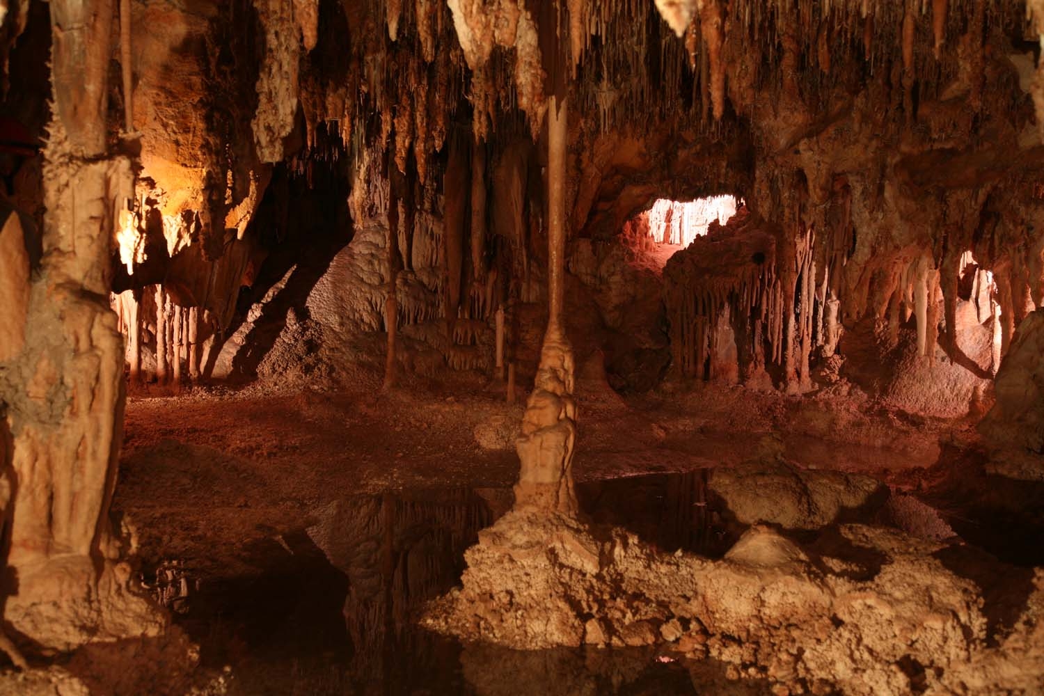
#19: This is the Doll’s Theater and can be seen if visitors take the Big Room Route at Carlsbad Caverns National Park in New Mexico. Carlsbad Caverns had 381,058 visitors in 2012, giving it an overall popularity ranking of #139. NPS describes this park as: “Rocky slopes and canyons, cactus, grass, thorny shrubs, and the occasional tree, who could guess at the hidden treasures deep underground? Beneath this rugged land are more than 118 known caves – all formed when sulfuric acid dissolved the surrounding limestone.” Photo #13 by NPS

This park is 46,766 acres, has 117 caves — the longest of which is over 120 miles (190 km) long! The Big Room is about 4,000 feet (1,200 m) long. There are over 400,000 Mexican Free-tailed bats and sixteen other species that call the caves their home. The Chihuahuan Desert and Rattlesnake Springs are located above ground at Carlsbad. The cavern lighting gives this shot of the Hall of Giants green and yellow tones. The photographer wrote, “To save money Carlsbad Caverns is switching to the greener tint lightings which changes the overall effect.” Photo #14 by J.J. (SamuraiCatJB)

#18: Redwood National Park officials describe the park as: “Most people know Redwood as home to the tallest trees on Earth. But the parks also protect vast prairies, oak woodlands, wild riverways, and nearly 40 miles of pristine coastline, all supporting a rich mosaic of wildlife diversity and cultural traditions. Together, the National Park Service and California State Parks manage these lands for the inspiration, enjoyment, and education of all people.” It ranked #142 of all parks based on the 352,517 visitors in 2012. Photo #15 by Marc Soller

Harbor seals and seagulls at Redwood National Park. The park has 37 miles (60 km) of protected coastline that has tide pools and seastacks; the 112,512 acres of prairie, estuary, coast, river, and forest ecosystems have varied animal and plant species. Photo #16 by Buzz Hoffman

#17 for less people, more nature. The Rio Grande, separating Mexico from the U.S., within the massive 1,500 foot high walls of Santa Elena Canyon at Big Bend National Park in Texas. In 2012, the park had 292,055, ranking it at #153 in popularity. NPS described it as: “Splendid isolation, The Big Bend…There is a place in Far West Texas where night skies are dark as coal and rivers carve temple-like canyons in ancient limestone. Here, at the end of the road, hundreds of bird species take refuge in a solitary mountain range surrounded by weather-beaten desert. Tenacious cactus bloom in sublime southwestern sun, and diversity of species is the best in the country. This magical place is Big Bend.” Photo #17 by Robert Hensley

Tule Mountain in Big Bend National Park; Chihuahuan Desert with double rainbow. In total, the park has 801,163 acres. Photo #18 by cool.as.a.cucumber

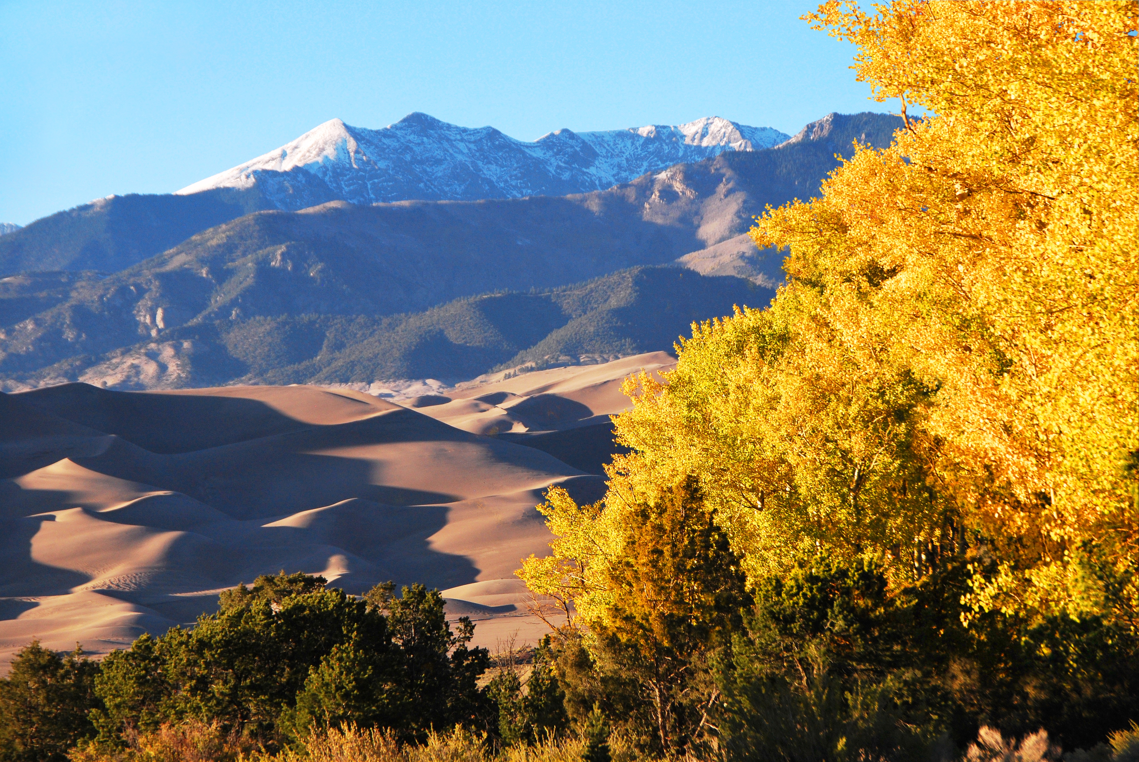
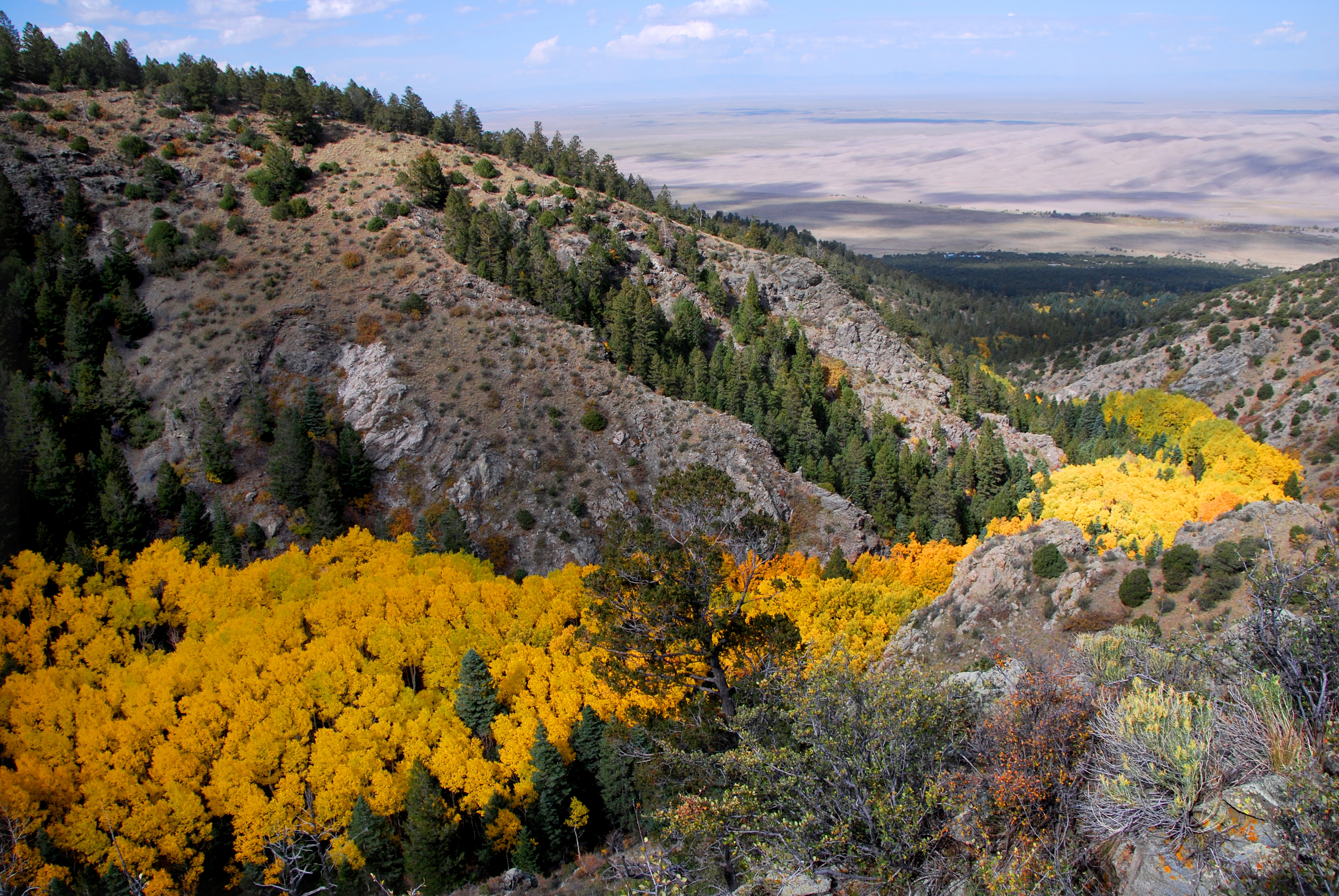
#16: Golden aspens, dunes, and Cleveland Peak at Great Sand Dunes National Park and Preserve in Colorado. It ranked at #168 of #367 for its 254,674 visitors in 2012. NPS described it as: “The tallest dunes in North America are the centerpiece in a diverse landscape of grasslands, wetlands, conifer and aspen forests, alpine lakes, and tundra. Experience this diversity through hiking, sand sledding, splashing in Medano Creek, wildlife watching, and more!”Photo #19 by NPS

Golden aspens look like a river as they follow the Morris Gulch drainage down toward the dunes. The 42,983 acres also has over 100 pine trees still living that had the bark culturally peeled for food and medicine by Ute, Apache, and other tribes. And on June 2, 2011, NPS said that “scientists recorded the ‘singing’ or ‘booming’ sand phenomenon at the park. Photo #20 by NPS

#15: Channel Islands National Park in California had 249,594 visitors in 2012, putting it in the rank of #169 of all NPS parks. It was described as: “Channel Islands National Park encompasses five remarkable islands and their ocean environment, preserving and protecting a wealth of natural and cultural resources. Isolation over thousands of years has created unique animals, plants, and archeological resources found nowhere else on Earth and helped preserve a place where visitors can experience coastal southern California as it once was.” Photo #21 by James Chang

Kelp forest and sardines, Anacapa Island, Channel Islands. The superb diving areas within the 249,561 acres offer a firsthand look at over half of the park’s resources as well as some of the most diverse ecosystems in the world. The U.S. Department of Justice stated, “The Land Acquisition Section secured sites for the expansion of Channel Islands National Park. The Park is located on five of the eight islands off the coast of Southern California in the Pacific Ocean. Congress created the National Park in 1980 to protect the unique natural resources found on the islands and surrounding aquatic ecosystems. Sometimes referred to as America’s Galapagos, Channel Islands National Park is home to 145 species of animals and plants found nowhere else in the world. More than 10,000 years of continuous human occupation have been recorded on the Channel Islands, making the Islands’ archaeological sites the most well-preserved on the Pacific coast.” Photo #22 by Robert Schwemmer, NOAA National Marine Sanctuaries

#14: Voyageurs National Park in northern Minnesota was described by NPS as: “Voyageurs National Park lies within the heart of the North American Continent. Here you can see and touch rocks half as old as the world, experience the life of a voyageur, immerse yourself in the sights and sounds of a boreal forest, view the dark skies, or ply the interconnected water routes. So leave your car behind and set out on the water highways of the North Woods.” And 214,841 people did in 2012, causing Voyageurs to rank at #175. Photo #23 by jck_photos

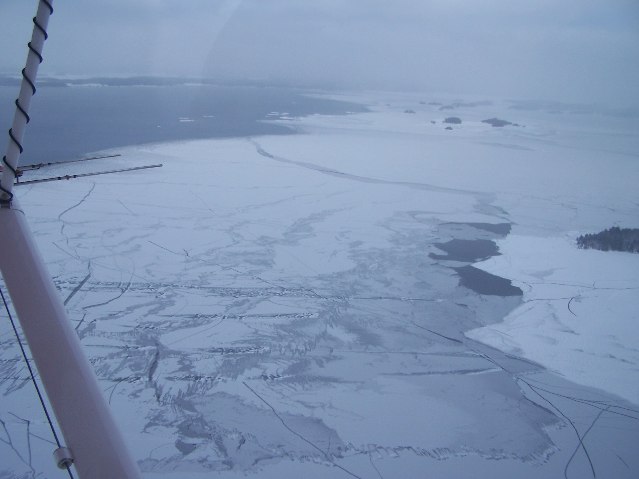
While there are nine hiking paths on the 218,200 acres of Voyageurs, most people come to play in the water such as by fishing, kayaking and canoeing the interconnected waterways. Being in Minnesota, winter is also key for this park, as NPS says, “Voyageurs National Park is an amazing place to visit in winter, when the surface of the park’s lakes will freeze up to two feet thick!” Brr! Photo #24 by NPS

#13: Inner canyon area at Black Canyon of the Gunnison National Park in Colorado. Last year, this park had 192,570 visitors, which ranked it at #183. NPSdescribed it as: “Big enough to be overwhelming, still intimate enough to feel the pulse of time, Black Canyon of the Gunnison exposes you to some of the steepest cliffs, oldest rock, and craggiest spires in North America. With two million years to work, the Gunnison River, along with the forces of weathering, has sculpted this vertical wilderness of rock, water, and sky.” Photo #25 by NPS / Lisa Lynch

Black Canyon of the Gunnison’s 32,950 acres include the steep canyon that is often shadowed, making the rock to appear black. Adventure lovers often partake in river rafting and climbing. Photo #26 by Jeff Kramer from Austin, US

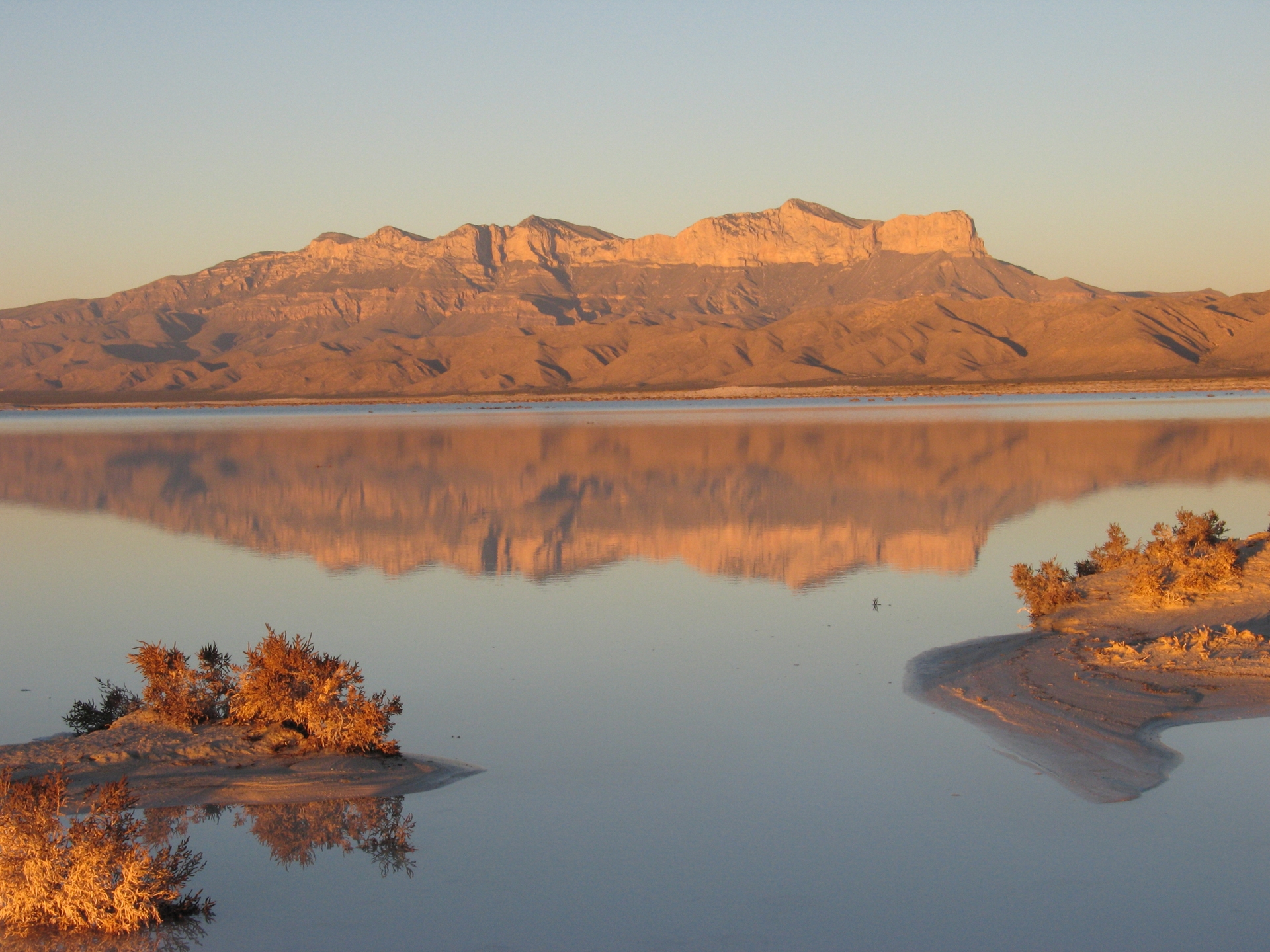
#12: Towering Sentinel El Capitan at Guadalupe Mountains National Park in Texas. Guadalupe Mountains NP ranked at #196 due to the 159,360 visitors in 2012. NPS described the park as: “Guadalupe Mountains National Park is the world’s premier example of a fossil reef from the Permian Era. The park is known for its extensive hiking and backpacking opportunities in one of the nation’s most pristine wilderness areas. Birding, history, and many other opportunities to learn and have fun await visitors in this hidden gem of West Texas.” Photo #27 by NPS

Mountain vista across the salt lake at Guadalupe Mountains National Park. The 86,367 acres contain Guadalupe Peak, the highest point in Texas at 8,749 feet, El Capitan that was used as a landmark by people traveling for thousands of years, and McKittrick Canyon. Photo #28 by NPS
")
#11: NPS describes Congaree National Park as: “Astonishing biodiversity exists in Congaree National Park, the largest intact expanse of old growth bottomland hardwood forest remaining in the southeastern United States. Waters from the Congaree and Wateree Rivers sweep through the floodplain, carrying nutrients and sediments that nourish and rejuvenate this ecosystem and support the growth of national and state champion trees.” In 2012, 109,685 people visited the park which gave it a ranking of #225. This is a shot of Congaree in April, alive and green. Photo #29 by Will Sweet

Since most of the park is designated wilderness, you can explore it by kayak or canoe. But there are also over 25 miles of hiking trails and 2.4 miles of boardwalk loop trail. This boardwalk loop trail cuts through the Congaree floodplain forest. The photographer warned that the walkway through the swamp was swamped. “Very high water. Don’t stray off route.” Congaree is 26,546 acres and has the largest portion of old-growth floodplain forest left in North America. Photo #30 by anoldent

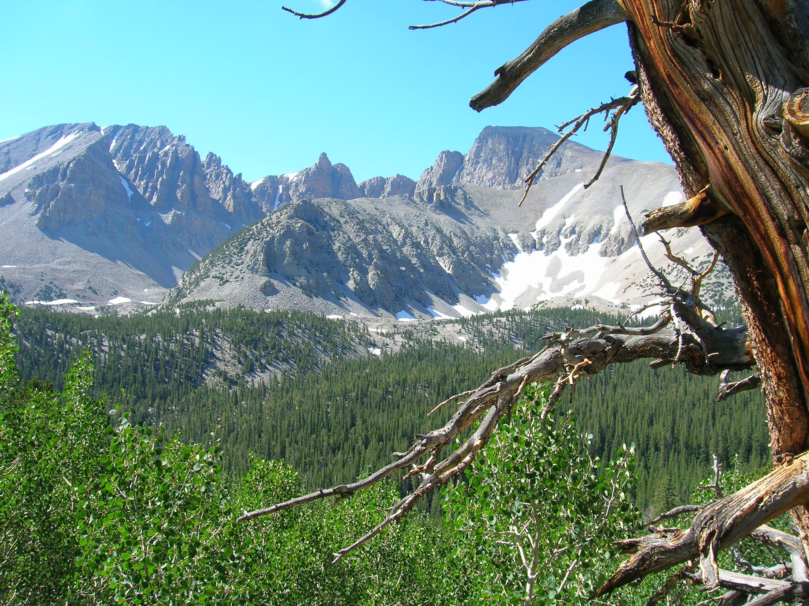
#10: Great Basin National Park in Nevada had 94,850 unique recreational visitors last year, giving it a park rank of #234 out of #367 total parks. NPSdescribes the park as: “In the shadow of 13,063-foot Wheeler Peak, 5,000 year old bristlecone pine trees grow on rocky glacial moraines. Come to Great Basin National Park to experience the solitude of the desert, the smell of sagebrush after a thunderstorm, the darkest of night skies, and the beauty of Lehman Caves. Far from a wasteland, the Great Basin is a diverse region that awaits your discovery.” This image is of Wheeler Peak on the way up the Summit Trail. Photo #31 by NPS

Great Basin is comprised of 77,180 acres. Many of park’s bristlecone pines were growing at the time the Egyptians were building the pyramids. Lehman Caves were discovered in the 1880s, but the park has over 40 known caves. The park is home to Lexington Arch, one of the largest limestone arches in the western United States. The Great Basin Desert is the only “cold” desert in America; most of the precipitation is in the form of snow. Within the park and neighboring valleys, there are 11 species of conifer trees, 73 species of mammals, 18 species of reptiles, 238 species of birds, 8 species of fish, and over 800 species of plants. Photo #32 by NPS

#9: Mount Blackburn from the southeast, looking up the Kennicott Glacier. The Wrangell-St. Elias National Park and Preserve in Alaska had 87,158 visitors last year, so the stats ranked it at #241. That may sound like quite a crowd of people in the park, but NPS described it as: “At 13.2 million acres which is bigger than the country of Switzerland, Wrangell-St. Elias stretches from one of the tallest peaks in North America, Mount St. Elias (18,008) to the ocean. Yet within this wild landscape, people have been living off the land for centuries and still do today. The park is a rugged yet inviting place to experience your own adventure.” Photo #33 by NPS

This blue glacial pool can be found at Wrangell, but 25 percent of the park is covered by glaciers. Not only is it the largest national park in the U.S., it is larger than nine U.S. states. The park includes an International Biosphere Reserve and is part of a UNESCO World Heritage Site. It also has the secondhighest elevation of all national parks within the USA. Photo #34 by Nate Verhanovitz / NPS

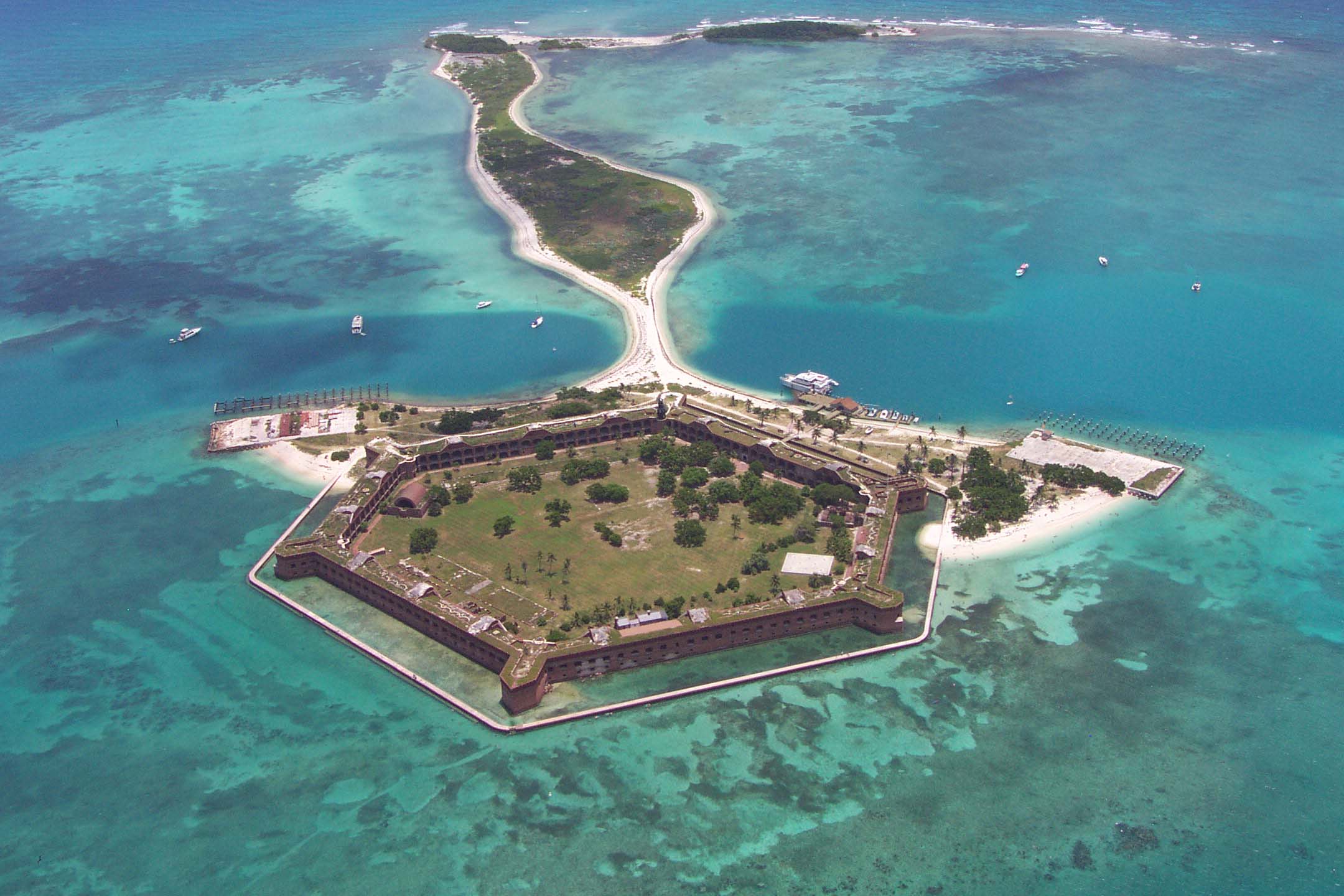
#8: Aerial of Fort Jefferson on Garden Key, part of Dry Tortugas National Park. It’s not the easiest park to reach, located at the farthest end of the Florida Keys, closer to Cuba than to the USA mainland. NPS describes it as: “Almost 70 miles (113 km) west of Key West lies the remote Dry Tortugas National Park. The 100-square mile park is mostly open water with seven small islands. Accessible only by boat or seaplane, the park is known the world over as the home of magnificent Fort Jefferson, picturesque blue waters, superlative coral reefs and marine life, and the vast assortment of bird life that frequent the area.” 60,550 people visited in 2012, giving it a rank of #260 of all 367 NPS parks. Photo #35 by National Park Service

Moat and turquoise crystal clear water at Dry Tortugas National Park. In those waters, there are more than 200 historic shipwrecks making it a hot spot for divers and underwater archaeologists. Photo #36 by Matt Kieffer

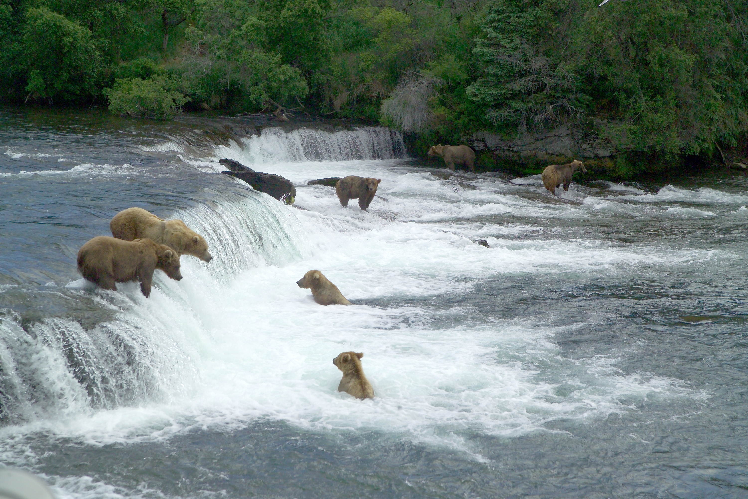
#7: Katmai Crater, Mount Katmai in Alaska is part of Katmai National Park and Preserve. 39,818 people visited the 4,093,077 acres park in 2012, giving it the rank of #287 of all NPS parks. It is described as: “Katmai National Monument was created in 1918 to preserve the famed Valley of Ten Thousand Smokes, a spectacular forty square mile, 100 to 700 foot deep ash flow deposited by Novarupta Volcano in 1912. A National Park & Preserve since 1980, today Katmai is still famous for volcanoes, but also for brown bears, pristine waterways with abundant fish, remote wilderness, and a rugged coastline.” 7 of 18 volcanoes at Katmai have been active since 1900. Photo #37 by Captain Budd Christman, NOAA Corps

Brown bears gathering near Brooks Falls to feast on sockeye salmon, Katmai National Park and Preserve. Most of the park is a designated wilderness area, meaning no hunting, which has allowed Katmai to have the world’s largest protected brown bear population estimated to be in excess of 2,100.Photo #38 by NPS

#6: NPS describes this wilderness adventure at Kobuk Valley National Park as: “Caribou, sand dunes, the Kobuk River, Onion Portage – just some of the facets of Kobuk Valley National Park. Half a million caribou migrate through, their tracks crisscrossing sculpted dunes. The Kobuk River is an ancient and current path for people and wildlife. For 9,000 years, people came to Onion Portage to harvest caribou as they swam the river. Even today, that rich tradition continues.” The 1,750,716 acres in Alaska ranked at #309, with only 29,550 visitors in 2012. Photo #39 by 16Terezka

Kobuk Valley National Park is located entirely above the Arctic Circle. There are no roads leading to the park, which is yet another reason it is so infrequently visited. Instead, visitors can reach the park by foot, dogsled, snowmobile, and chartered air taxis. “A Perfect Fall Day in the Wild,” wrote the photographer. “Clear, cool days are common in September in the park. The blue sky contrasts with the beautiful fall colors on the tundra in the upper Salmon River drainage.” There are three sets of sand dune fields on the south side of the Kobuk River: The Great Kobuk Sand Dunes, Little Kobuk Sand Dunes and the Hunt River Dunes. Photo #40 by Western Arctic National Parklands

#5: Sahale Mountain and Doubtful Lake in the North Cascades National Park. Ranking at #313 with only 26,935 total visitors in 2012, NPS describes it as: “These mountains are calling for you. Less than three hours from Seattle, an alpine landscape beckons. Discover communities of life adapted to persistent moisture in the west and recurrent fire in the east — all sensitive to climate change. Explore jagged peaks crowned by more than 300 glaciers. Contemplate waterfalls cascading into deep valleys. Help steward the ecological heart of the Cascades.” Photo #41 by im me

Diablo Lake Overlook at North Cascades National Park, July 4, 2012. The 504,781 acres are located “in the state of Washington. The park is the largest of the three National Park Service units that comprise the North Cascades National Park Service Complex. Several national wilderness areas and British Columbia parkland adjoin the National Park. Nearly all of the national park is protected as the Stephen Mather Wilderness, so there are few maintained buildings and roads within the North and South units of the Park. The park is most popular with backpackers and mountain climbers. One of the most popular destinations in the park is Cascade Pass, which was used as a travel route by Native Americans.” Photo #42 by Jeff Few

#4: Sunrise on Tobin Harbor at Isle Royale National Park, taken from a canoe. This national park had a total of 16,663 visitors, ranking at #337, and the fourth least crowded national park in America. It offers both isolation and wilderness, having been designated as a National Wilderness Area and an International Biosphere Reserve. NPS describes it as: “Explore a rugged, isolated island where wolves and moose abound, far from the sights and sounds of civilization. Surrounded by Lake Superior, Isle Royale offers unparalleled solitude and adventures for backpackers, hikers, boaters, kayakers, canoeists and scuba divers. Here, amid stunning scenic beauty, you’ll find opportunities for reflection and discovery, and make memories that last a lifetime.” Photo #43 by Paul Huber

Tobin Harbor Trail through Laurentian Forest habitat at sunset. Isle Royale National Park is the largest island in Lake Superior. It has many shipwrecks, waterways, and hiking trails, and includes over 400 smaller islands in the waters up to 4.5 miles from the island. Photo #44 by MDuchek

#3: The third least-crowded national park is also a preserve, Lake Clark NP & Pres. With only 11,639 visitors, it ranked at #343 of 367 in 2012. NPSdescribes it as: “Lake Clark National Park is a land of stunning beauty where volcanoes steam, salmon run, bears forage, craggy mountains reflect in shimmering turquoise lakes, and local people and culture still depend on the land and water of their home. Solitude is found around every bend in the river and shoulder of a mountain. Venture into the park to become part of the wilderness.” Photo #45 by Melissa Blair, NPCA

The 4 million acres encompass rugged mountains, glacial ice, placid lakes, coastal beaches and salt marshes, active volcanoes, dense forests, alpine tundra and more. This is an ascending eruption cloud from Redoubt Volcano, in 1990, at Lake Clark National Park and Preserve. Photo #46 by R. Clucas / USGS

#2: The second least-visited national park in the USA is Gates of the Arctic NP & Preserve. It was ranked at #345, with only 10,899 visitors in all of 2012. NPS describes it as: “This vast landscape does not contain any roads or trails. Visitors discover intact ecosystems where people have lived with the land for thousands of years. Wild rivers meander through glacier-carved valleys, caribou migrate along age-old trails, endless summer light fades into aurora-lit night skies of winter. It remains virtually unchanged except by the forces of nature.” This is June sunshine on Gates of the Arctic National Park and Preserve. Photo #47 by Zak Richter/NPS

In July: Fog, mountains and beautiful blue water, perhaps Arrigetch Lake, at Gates of the Arctic National Park and Preserve. This park has 7,523,897.74 acres and is home to Alaska natives, who have relied on the land and caribou for 11,000 years. Photo #48 by ilya_ktsn

The #1 least visited national park in 2013 was the National Park of American Samoa. It ranked at #347 of all 367 parks controlled by NPS, and was the last listed area with the “national park” in its name. There were only 10,440 total visitors. It is also the only American national park located below the equator. NPS describes this national park as being “on three volcanic and mountainous islands clothed in tropical rainforest, ringed with rugged cliffs, glistening beaches, and coral reefs.” This is the beach at Ofu, American Samoa. Photo #49 by Peter Craig, National Park Service

The National Park of American Samoa is on American Samoa and spread over three separate islands: Tutuila, Ofu-Olosega, and Ta‘ū. “The park includes coral reefs and rain forest and is popular for hiking, snorkeling, and scuba diving, although the primary purpose of the park is that of preservation of Samoa’s unique natural resources.” Pictured above is Pola Ridge forest, located in the Tutuila unit of the park. It’s “on the north end of the island near Pago Pago. It is separated by Mount Alava (1,610 feet (490 m)) and the Maugaloa Ridge and includes the Amalau Valley, Craggy Point, Tafeu Cove, and the islands of Pola and Manofa. It is the only part of the park accessible by car and attracts the vast majority of people.” Photo #50 by NPS
- الحصول على الرابط
- X
- بريد إلكتروني
- التطبيقات الأخرى
تعليقات
إرسال تعليق